

Cue the sirens
Tornado catches Tulsa by surprise
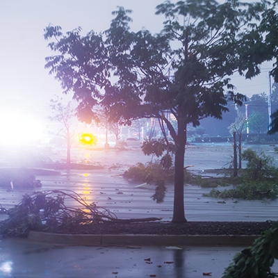
Tornado damage near 41st and Yale on August 6
David Lackey
Early on Sunday morning, August 6, 2017, heavy, low-hanging storm clouds gathered in midtown Tulsa. Thunder and rain and 40 mph winds drenched the streets, neighborhoods, and businesses that were not yet clear of Saturday night revelers. Suddenly, within 90 seconds, 40 mph winds increased to 125 mph. An EF2 tornado had formed without warning, striking the 41st and Yale area, and taking everyone by surprise—including the National Weather Service and the Tulsa Area Emergency Management Agency.
Weather apps and National Oceanic and Atmospheric Administration (NOAA) Weather Radios did not go off until after the tornado had touched down; the outdoor warning system was not activated at all. One hundred and seventy-three businesses and 25 homes were damaged or destroyed. Thirty injuries were reported.
Roger Jolliff, director of Tulsa Area Emergency Management Agency (TAEMA) and Steven Piltz, meteorologist in charge at the National Weather Service Tulsa (NWS) explained what happened, what didn’t happen, and why.
When it comes to tornado tracking and warning, the monitoring and warning tasks are shared between the NWS and local emergency management. The NWS monitors the radar, interprets the data, and when they put out a warning, they contact TAEMA, who then decides when and if to activate the Outdoor Warning System—emphasis on “Outdoor.”
The Outdoor Warning System is designed to warn those outdoors to take cover. For indoor warnings, keep your radio or TV tuned to your local stations, purchase a NOAA Weather Radio, or use one of the many free apps available for warnings, including the TulsaReady app and the NWS Weather Alert app.
“Every one of those meteorologists at the NWS has a degree in meteorology,” Jolliff said. “They have training, they have experience. They live the radar. They live the interpretation of the radar. When they issue the warning, we make our decision.”
So where were outdoor warning sirens on Sunday morning?
Piltz explained that if a storm organizes and touches down over a populated area, a better case scenario is “to have these circulations develop at 3,000–5,000 feet, and gradually strengthen. Then you can make a determination that gives 5–15 minutes of lead time. But the tornado we had over the weekend formed quickly, over a populated area, with a line of thunderstorms that was very low to the ground, and by the time we detected it on radar, it was already doing damage.”
“When a storm blows up as fast as this one did—by the time we got the warning, it was out of our city,” Joliff said. “To have sounded the sirens after the tornadic cell was outside of Tulsa would have been wrong. At that point, the damage was already done.”
The Storm Prediction Center in Norman is the national center for predicting long-term storm forecasts. Their role is to identify and to forecast atmospheric conditions days into the future.
“They did not issue a tornado watch because the science wasn’t there to support it,” Jolliff said.
But weather changes, he empathized. And sometimes it changes within seconds, making time a significant factor when interpreting weather radar.
Radar data, once received, is not cut and dry. It can have several meanings, and must be interpreted within the framework of a number of different factors, including topography and the area covered by the Doppler radar (if the beam is too broad, a rotating cloud may appear as turbulence, and if the storm is at a low altitude, it may not be caught by the radar at all).
Radar data takes time to interpret. Perhaps 30–90 seconds to understand the data, perhaps another radar scan is needed. Once a meteorologist spots a tornado, it takes another 60–90 seconds to create the warning and develop the message.
“So in the case of this storm,” Piltz said, “if you waited three minutes to interpret your data and then form your warning
message, it’s already moved four to five miles across southeast Tulsa since the time it hit 41st and Yale.”
The storm formed low to the ground over a populated area so rapidly that the NWS had no time to give a warning, and too late to activate the Outdoor Warning System. In this kind of situation, there was no fault, or failure.
“People should be able to questions us,” Jolliff said. “It’s healthy. We are always working to get better at this.”
And Jolliff hopes that the important discussion about warning systems will eventually include preparedness efforts, and what you can do to make your family safer during severe weather.
“Develop your family preparedness plan, your supply kit, have your home equipped to survive three days without power and three days without access to a grocery store. Have a safe place in your home where you go to take cover with virtually no notice. Doing these things will increase your chances of survival.”
“We want to think that weather is planned out for days, like we plan our personal schedules,” Jolliff said. “But weather can change in mere seconds.” Warning or no, we should all be ready when it does.

.jpg)
.jpg)